
Gorizia, in Friuli-Venezia Giulia near the border with Slovenia, is a small town and can be easily visited on foot; here are some walks we recommend. See our suggested walking tour in Gorizia below!
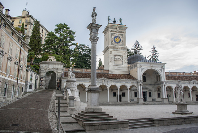
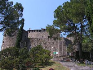
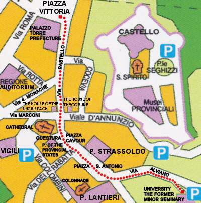
A tour of the town must begin from its most significant monument, the imposing Castle, surrounded by the ancient irregular walls (See map 1 below).
Founded in early medieval times, probably in the XIth century, the Castle was damaged, destroyed, and restructured many times in the course of centuries, and was finally restored to its original aspect by well carried out restoration work in 1937. Let’s see the tour in Gorizia, Friuli- Venezi Giulia.
Walking tour in Gorizia, Italy

Borgo Castello, Gorizia
The Castle of Gorizia is today a robust and articulate construction in the shape of a pentagon around the wide Court of the Lanzi. From the Court, one accesses the thirteenth-century Palazzetto of the Counts, the west part of the Castle, distinguishable for its five Romanesque two-light windows, and the fifteenth-century Palace of the Provincial States.
The east part, connected to the Palazzetto by means of a connecting structure called Palazzetto Veneto. The rooms in the Castle are furnished with period furniture: on the ground floor, one can admire the small dining room and the kitchen, with medieval furniture and implements. Also on the ground floor is the Hall of the Knights, where there are some interesting copies of arms and armors.
The “representation” halls are on the main floor: the Count’s Hall, now used for conferences and congresses, and the Hall of the Provincial States, large and embellished with a superb caisson ceiling, paintings, and parts of frescos, a splendid framework for important exhibitions. Finally, the Music Hall contains several copies of medieval instruments.
On the second floor is the Palatine Chapel, embellished with a beautiful collection of works of art from the Venetian school, and the so-called “Granary”, a didactic hall of the County Museum: here there are models of the ancient County, the medieval town and the Castle.
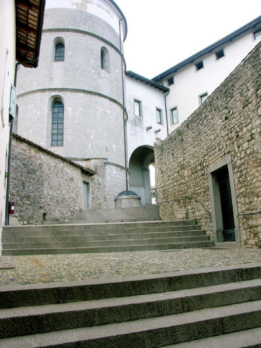
Continuing the walking tour in Gorizia with Borgo Castello. Leaving the palace we can take the “Patrol Trench”, an enchanting short walk with a magnificent view of the city.
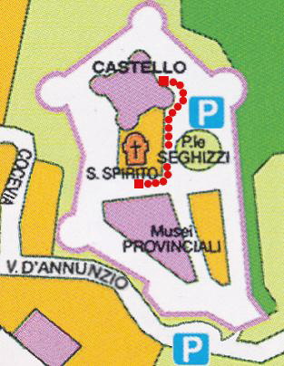
Map 2: The path from the Castle main entrance to the Church of the Holy Spirit
In Borgo Castello, it is worth visiting the pretty Church of the Holy Spirit (XVth century) (See map 2 below), built by the Rabatta brothers and characterized by a facade with a small belfry in the shape of a three-light window, and the Provincial Museums, housed in a seventeenth-century building, formerly owned by the Formentini, and in the Dornberg and Tasso houses.
Continuing the walking tour in Gorizia
The Provincial Museums offer visitors rich collections of different kinds of objects and works of art, some of which are interesting in terms of history or folklore, others of great value in terms of art (See map 3 below).
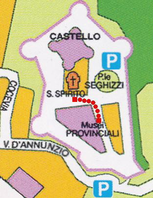
Map 3: The path from the Church of the Holy Spirit to the Provincial Museums
Outside Borgo Castello the tour continues along streets and squares overlooked by the palazzos of the town nobility.
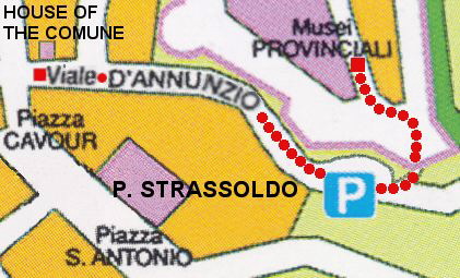
Map 4: The path from the Provincial Museums to the House of the Comune
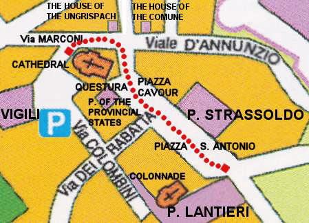
After walking down Via D’Annunzio we come to Piazza Cavour, enriched by the elegant and sober Palace of the Provincial States, the sixteenth-century House of the Comune (See map 4 above), and the House of the Ungrispach (See map 5 below), on the facade of which there is a sign bearing the date “MCCCCXLI” in Roman figures.
Map 5: The path from the House of the Comune to the House of the Ungrispach
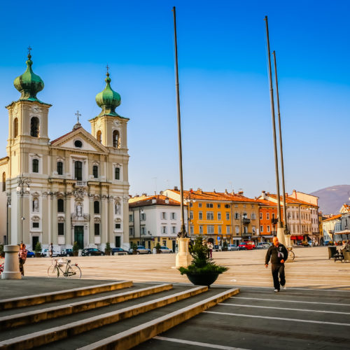
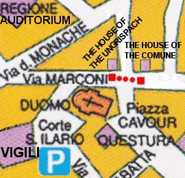
If you continue your walking tour in Gorizia, you’ll see near Piazza Cavour, the Court of Saint Ilario. The court shows up dominated by the imposing bulk of the Cathedral, a church devoted to Saint Ilario and Saint Taziano (See map 6 below).
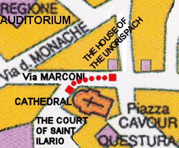
Map 6: The path from the House of the Ungrispach to the main entrance of the Cathedral
The present facade is the fruit of a restructuring done after the First World War: the reconstruction was entrusted to the architect E. Araman. Of the original fourteenth-century nucleus, survives only the vestibule of the altar of the Most Holy Sacrament, which, in the XV century, was connected to the Chapel of Saint Acazio, that had been built according to the will of the Counts of Gorizia: the union of the two structures generated a new church, completed in 1525. The building was modified again in the XVII century and, as already mentioned, there have been more recent modifications. Inside one can admire the high altar in marble, with the statues of Saint Ilario and Saint Taziano, made in 1708 by Giovanni and Leonardo Pacassi.
Overlooking the nearby Piazza Saint Antonio, besides a slim colonnade, there are Palazzo Lantieri and the Palace of the Counts of Strassoldo, the only existing parts of an old convent, which, it is said, had been founded by the Sainted Abbot: the former developed from a fourteenth-century guesthouse, that the Counts of Gorizia had ordered to be built, and that is connected to the castle by an underground passage. The guesthouse, known as Schoenhaus, was left by the last Count of Gorizia to his personal physician, who sold it in 1505 to the nobleman Antonio Lantieri. The Lantieri embellished and enlarged the palazzo, and emperors and famous people were guests there. The latter also developed around an ancient nucleus, but its present features are due to rebuilding in the late XVI century (See map 7 below).
Map 7: The path from the Cathedral to Piazza Saint Antonio
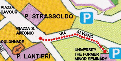
Let’s now continue the walking tour in Gorizia. From the square we turn into Via Alviano, to see the Palazzo of the former Minor Seminary, built for the archbishop Sedej between 1908 and 1912, and now University premises (See map 8 below).
Map 8: The path from Piazza Saint Antonio to the University, the former Minor Seminary
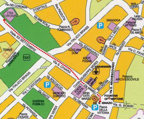
Returning to Piazza Cavour and turning into Via del Rastello we come to Piazza della Vittoria (See map 9 below), dominated by the fairytale Fountain of Neptune, designed by Nicola Pacassi; Palazzo Torre overlooks the square, once owned by the homonymous counts, who had it built in 1540 and today, after several modifications and enlargements, it is the headquarters of the Prefecture.
Map 9: The path from the University to Piazza Vittoria
From Piazza della Vittoria we can reach the Church of Saint Ignazio, a baroque building erected by the Jesuits in 1654 but only completed in the middle of the following century.
From Piazza della Vittoria and turning into Via Mameli, the Werdenberg Palace can be admired, built between 1655 and 1747 to house the Jesuit College. Now it houses the State and Civic Library.
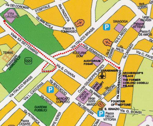
From via Mameli by way of via Santa Chiara we come to Viale XX Settembre, where the beautiful sixteenth-century Coronini Cronberg Palace stands (See map 10 below): the Palace and the splendid park surrounding it were donated to the city of Gorizia by the last owner, Count Guglielmo Coronini.
Map 10: The path from Piazza Vittoria to the Coronini Cronberg Palace
Inside the building, eighteenth-century lacquered furniture in Venetian style, oriental carpets, precious cloths, porcelain, Japanese prints and sketches, Russian silver, and paintings datable from the XVIth to the XXth century are conserved. There is also a rich library consisting of over ten thousand volumes of manuscripts and ancient books, and the Archive of the Coronini Counts. Continuing the walking tour in Gorizia, we’ll explore even more!
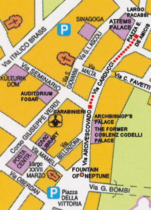
Walking back Viale XX Settembre towards the center, before entering Via Santa Chiara, it is possible to turn right into Via Cadorna and go down the steps that lead to Via Brass. Walking down Via Brass up to the crosslight and turning right into Via del Seminario, we arrive at one end of Via Carducci. Here stands the Coblenz Codelli Palace, built at the end of the sixteenth century but greatly enlarged following the addition of the Oratory devoted to the Holy Cross. In 1749 the Palace became the headquarters of the Archbishopric (See map 11 below).
Map 11: The path from the Coronini Cronberg Palace to the Archbishop’s Palace
Via Carducci ends in Piazza De Amicis, where we can admire the facade of what is probably the most beautiful building in town, the Attems Petzenstein Palace (See map 12 below), designed by Pacassi and built between 1733 and 1745; since the early twentieth century, it has housed the Provincial Museums.
Map 12: The path from the Archbishop’s Palace to the Attems Petzenstein Palace
From Piazza De Amicis we walk up Via Silvio Pellico and we come to a small square named Piazza Medaglie d’Oro (See map 13 below); we walk down Via Monte Santo as far as the junction of Via Monte Santo and Via Caprin; turning right and walking down Via Caprin, we reach Piazza Transalpina (See map 14) dominated by the historical railway station. This station was inaugurated in 1906 in the presence of several members of the Hapsburg royal family. It was the second station to be opened in the city, after the so-called “Meridionale”, built in the second half of the nineteenth century, which is now the Central Station of Gorizia. The Transalpina line connected the coast directly with Austria.
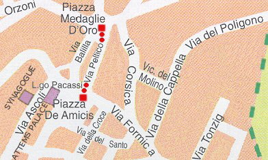
Map 13: The path from Piazza De Amicis to Piazza Medaglie d’Oro
It had been decided by the government of Vienna for military purposes as a “second road to Trieste”, in order to have a direct railway line to the southern provinces of the Austrian-Hungarian Empire without having to go through Udine. Nowadays, although the Transalpina is a charming line in terms of the scenery it passed through, it is a secondary line with a single non-electrified track, linking the Valley of the Isonzo and the Julian Alps to Sezana and Jesenice, from where one can go on towards Austria. For the past few years, programmed rides on historic trains have been organized. These fascinating steam engines take tourists from Gorizia to the lake of Bled.
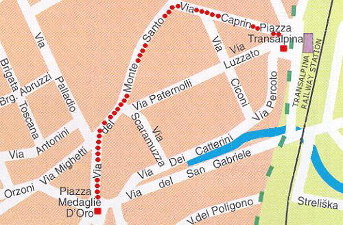
Map 14: The path from Piazza Medaglie d’Oro to Piazza Transalpina
In front of the elegant and impressive station building, there is a big square decorated with a mosaic created by the artist Franco Vecchiet from Trieste, on the occasion of Slovenia’s entry into the European Union. The mosaic is a metaphoric and poetic representation of the peaceful explosion of the milestone that, until not long ago, marked the border between Gorizia and Nova Gorica; now it epitomizes European integration.
Inside the railway station building is located the Border Museum; it has an exhibition on life on the territory of Gorizia from 1945 to 2004.
From Piazza Transalpina we go back to Piazza De Amicis and from Piazza De Amicis to Via Ascoli: this area was once the Jewish Ghetto and the Synagogue is here, an imposing nineteenth-century building with sober features. The present building was built towards the mid-eighteenth century to replace a more modest wooden building. The successive restructuring carried out in the XIX century gave it its present features, sober but elegant. Inside one can visit the very interesting didactic Museum of the “Little Jerusalem on the Isonzo” (according to the name defining the local Hebrew community), enriched with a section devoted to the great philosopher from Gorizia, Carlo Michelstaedter. Beyond the Synagogue, we come to Via San Giovanni, with the homonymous late sixteenth-century church later owned by the Jesuits.
Leaving Via San Giovanni at one’s back and going down Corso Giuseppe Verdi, up to the crossroads with Via Garibaldi on the left side, and Via Diaz on the right one, we come to the nineteenth-century Evangelical Methodist Church, built according to the directions of Giovanni Pitteri.
In Via Garibaldi one can see the Church of the Immaculate, a small building conserving some interesting paintings.
By continuing the walking tour in Gorizia, from Via Garibaldi we come to Piazza Municipio. There stands the present Town Hall, in the eighteenth-century Palazzo Attems Santa Croce: this building too was designed by the great architect from Gorizia, Nicola Pacassi.
Keeping the Palazzo Attems Santa Croce on the left and walking on, we reach the courthouse and, further on, turning left at the corner in the direction of the Slovene border, we come to Piazza San Francesco, dominated by the Church of Santa Maria Assunta, formerly annexed to a Capuchin Convent that was destroyed during the First World War. The Church dates back to the late sixteenth century, but its features today are due to a reconstruction carried out in the early twentieth century.
From the square, walking down Via Vittorio Veneto, we come to another small square; turning left, we go a little out of our way to see Piazza San Rocco, where the church was built in honor of the saint who protected the city during the fury of a terrible pestilence: the church is embellished with a painting credited to Palma il Vecchio.
Northwards, not far from the town center of Gorizia, in the locality of Oslavia, where stands the Sacrarium, a war memorial which commemorates the fallen of the First World War. Built-in 1938, it looks like a fortress dominated by a great tower; the crypt is at the center of a triangular area with three towers at its corners. In the Sacrarium, over 57,000 bodies of Italian soldiers and 539 of Austrian-Hungarian soldiers rest in peace, after having been exhumed from the War Cemeteries on the Plateau of the Bainsizza al Vipacco. On the left of the Sacrarium is the Votive Bell offered by the war veterans.
Hope you enjoyed this walking tour in Gorizia, Italy.
Comune di Gorizia